Skip to content (Press Enter)
Scottish Outdoor Access Network

Scottish Outdoor Access Network

For people working in outdoor access across Scotland

  • Home
  • About Us
    • History of SOAN
    • Our Mission
    • Our Committee
    • SATIN
  • About Access
    • History of Outdoor Access
    • Outdoor Access Today
    • Managing Outdoor access
    • Active Travel
  • Join Us
  • Events
  • Ask SOAN
  • News
  • Privacy Policy
Scottish Outdoor Access Network

Scottish Outdoor Access Network

For people working in outdoor access across Scotland

  • Home
  • About Us
    • History of SOAN
    • Our Mission
    • Our Committee
    • SATIN
  • About Access
    • History of Outdoor Access
    • Outdoor Access Today
    • Managing Outdoor access
    • Active Travel
  • Join Us
  • Events
  • Ask SOAN
  • News
  • Privacy Policy
The point of a green arrow and a Saltire

Case Studies

22
  • Bankier Primary School Path, Banknock, Falkirk
  • Connel Ferry Station School Transport Improvements
  • Bracklinn Bespoke Steel Timber Bridge
  • Cawder ‘Warren Truss’ Bridge
  • Dorrator ‘Steel Truss’ Bridge
  • Delivering Upland Path Maintenance in the Cairngorms
  • Geocomposite – Lochgilphead Shared Use Path
  • Upland path repairs protecting Steall Gorge
  • Rural Path Surfacing – Islay, Argyll and Bute
  • Ultitrec – Wilkies Path, Drymen
  • Use of Locally Won ‘As Dug’ Materials for Path Construction
  • Use of KBI Flexi™-Pave on Trans Pennine Trail
  • Auchterarder Shared Use Path, Phase 2
  • Loch Earn Railway Path
  • John Muir Way (Blackness to Bo’ness Section)
  • Bridgeness Biodoversity Project
  • Clyde Walkway – Use of Smart Surface® Soil Stabilisation Technique
  • Bowline Project at Bowling Harbour, Glasgow
  • Welcome to the SATIN Case Studies
  • ‘Mires Path’ Boardwalk Replacement
  • Battleby House to Redgorton Active Travel Path
  • Stockingfield Junction Footbridge, Glasgow
The point of a green arrow and a Saltire

Technical A to Z

3
  • Access Control and Management
  • Welcome to the SATIN Technical A – Z
  • Access Authorities
The point of a green arrow and a Saltire

Training

1
  • Scottish Access Rights Training Course
View Categories
  • Home
  • Ask SOAN
  • Case Studies
  • John Muir Way (Blackness to Bo’ness Section)

John Muir Way (Blackness to Bo’ness Section)

< 1 min read

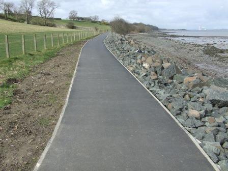
This projects delivery has substantially improved a section of the John Muir Way Coast to Coast long distance route, and through its delivery has completed a high quality walking and cycling route between Blackness and Bo’ness. The project has re-established a route between the two communities and through its design and delivery has developed it into an all-weather multi-use route, which now provides a safe off road route between these two destinations and will enable the re-alignment of the National Cycle Network NCN 76 route. The route now offers the easiest of gradients possible and its delivery has enabled people living in the local communities to use the route as part of their everyday travel choice. The gentle gradient has also encouraged people who are less active to try cycling or walking as the first steps towards a more active lifestyle or for those more adventurous souls to walk parts of the John Muir Way.

Download the case study.

Updated on 11 October 2025
Active travel construction materials cycle path path surfaces Shared use path

Was this useful to you?

  • Happy
  • Normal
  • Sad

Share This Article :

  • Facebook
  • X
  • LinkedIn
  • Pinterest
Loch Earn Railway PathBridgeness Biodoversity Project

Copyright © Scottish Outdoor Access Network

Privacy Policy

Scroll