Skip to content (Press Enter)
Scottish Outdoor Access Network

Scottish Outdoor Access Network

For people working in outdoor access across Scotland

  • Home
  • About Us
    • History of SOAN
    • Our Mission
    • Our Committee
    • SATIN
  • About Access
    • History of Outdoor Access
    • Outdoor Access Today
    • Managing Outdoor access
    • Active Travel
  • Join Us
  • Events
  • Ask SOAN
  • News
  • Privacy Policy
Scottish Outdoor Access Network

Scottish Outdoor Access Network

For people working in outdoor access across Scotland

  • Home
  • About Us
    • History of SOAN
    • Our Mission
    • Our Committee
    • SATIN
  • About Access
    • History of Outdoor Access
    • Outdoor Access Today
    • Managing Outdoor access
    • Active Travel
  • Join Us
  • Events
  • Ask SOAN
  • News
  • Privacy Policy
The point of a green arrow and a Saltire

Case Studies

22
  • Bankier Primary School Path, Banknock, Falkirk
  • Connel Ferry Station School Transport Improvements
  • Bracklinn Bespoke Steel Timber Bridge
  • Cawder ‘Warren Truss’ Bridge
  • Dorrator ‘Steel Truss’ Bridge
  • Delivering Upland Path Maintenance in the Cairngorms
  • Geocomposite – Lochgilphead Shared Use Path
  • Upland path repairs protecting Steall Gorge
  • Rural Path Surfacing – Islay, Argyll and Bute
  • Ultitrec – Wilkies Path, Drymen
  • Use of Locally Won ‘As Dug’ Materials for Path Construction
  • Use of KBI Flexi™-Pave on Trans Pennine Trail
  • Auchterarder Shared Use Path, Phase 2
  • Loch Earn Railway Path
  • John Muir Way (Blackness to Bo’ness Section)
  • Bridgeness Biodoversity Project
  • Clyde Walkway – Use of Smart Surface® Soil Stabilisation Technique
  • Bowline Project at Bowling Harbour, Glasgow
  • Welcome to the SATIN Case Studies
  • ‘Mires Path’ Boardwalk Replacement
  • Battleby House to Redgorton Active Travel Path
  • Stockingfield Junction Footbridge, Glasgow
The point of a green arrow and a Saltire

Technical A to Z

3
  • Access Control and Management
  • Welcome to the SATIN Technical A – Z
  • Access Authorities
The point of a green arrow and a Saltire

Training

1
  • Scottish Access Rights Training Course
View Categories
  • Home
  • Ask SOAN
  • Case Studies
  • Clyde Walkway – Use of Smart Surface® Soil Stabilisation Technique

Clyde Walkway – Use of Smart Surface® Soil Stabilisation Technique

< 1 min read

The Clyde Walkway is a 65km/40mile route from Glasgow City Centre to the World Heritage Site of New Lanark. It passes through some spectacular scenery and many interesting and important sites which offer insights into the rich cultural, natural and industrial heritage of the Clyde Valley.

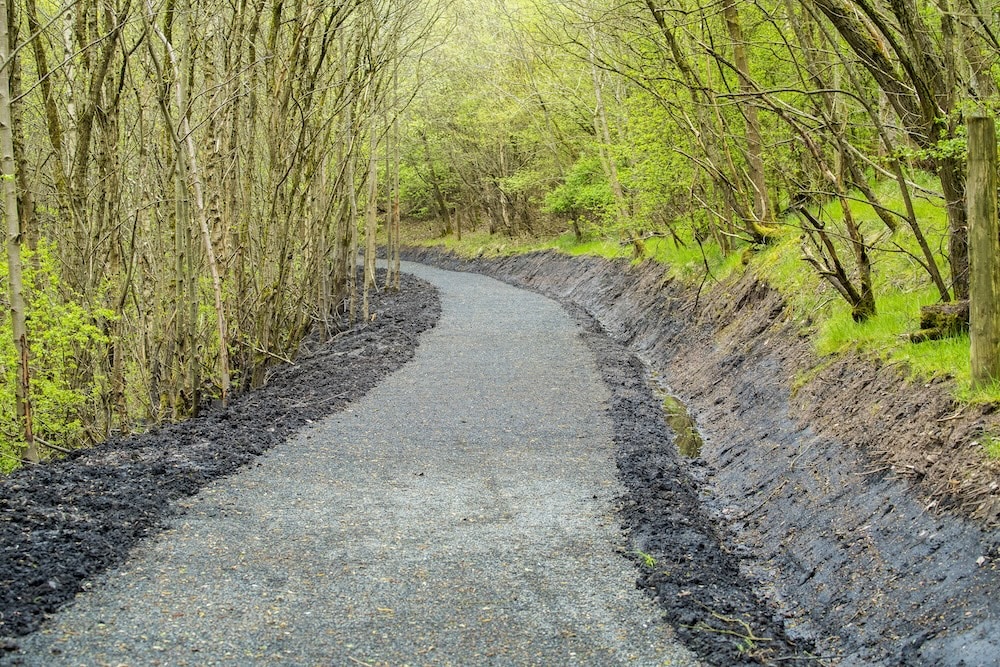
This project used an innovative approach to path surface renovation. Part of the route had been subject to past improvement works however the condition of the path surface had deteriorated considerably over those years with significant areas of mud, water erosion, encroaching vegetation and decayed timber edging. This project used a soil stabilisation process to improve the path.

Download the case study.

Updated on 10 October 2025
construction materials path surfaces

Was this useful to you?

  • Happy
  • Normal
  • Sad

Share This Article :

  • Facebook
  • X
  • LinkedIn
  • Pinterest
Bridgeness Biodoversity ProjectBowline Project at Bowling Harbour, Glasgow

Copyright © Scottish Outdoor Access Network

Privacy Policy

Scroll