Skip to content (Press Enter)
Scottish Outdoor Access Network

Scottish Outdoor Access Network

For people working in outdoor access across Scotland

  • Home
  • About Us
    • History of SOAN
    • Our Mission
    • Our Committee
    • SATIN
  • About Access
    • History of Outdoor Access
    • Outdoor Access Today
    • Managing Outdoor access
    • Active Travel
  • Join Us
  • Events
  • Ask SOAN
  • News
  • Privacy Policy
Scottish Outdoor Access Network

Scottish Outdoor Access Network

For people working in outdoor access across Scotland

  • Home
  • About Us
    • History of SOAN
    • Our Mission
    • Our Committee
    • SATIN
  • About Access
    • History of Outdoor Access
    • Outdoor Access Today
    • Managing Outdoor access
    • Active Travel
  • Join Us
  • Events
  • Ask SOAN
  • News
  • Privacy Policy
The point of a green arrow and a Saltire

Case Studies

22
  • Bankier Primary School Path, Banknock, Falkirk
  • Connel Ferry Station School Transport Improvements
  • Bracklinn Bespoke Steel Timber Bridge
  • Cawder ‘Warren Truss’ Bridge
  • Dorrator ‘Steel Truss’ Bridge
  • Delivering Upland Path Maintenance in the Cairngorms
  • Geocomposite – Lochgilphead Shared Use Path
  • Upland path repairs protecting Steall Gorge
  • Rural Path Surfacing – Islay, Argyll and Bute
  • Ultitrec – Wilkies Path, Drymen
  • Use of Locally Won ‘As Dug’ Materials for Path Construction
  • Use of KBI Flexi™-Pave on Trans Pennine Trail
  • Auchterarder Shared Use Path, Phase 2
  • Loch Earn Railway Path
  • John Muir Way (Blackness to Bo’ness Section)
  • Bridgeness Biodoversity Project
  • Clyde Walkway – Use of Smart Surface® Soil Stabilisation Technique
  • Bowline Project at Bowling Harbour, Glasgow
  • Welcome to the SATIN Case Studies
  • ‘Mires Path’ Boardwalk Replacement
  • Battleby House to Redgorton Active Travel Path
  • Stockingfield Junction Footbridge, Glasgow
The point of a green arrow and a Saltire

Technical A to Z

3
  • Access Control and Management
  • Welcome to the SATIN Technical A – Z
  • Access Authorities
The point of a green arrow and a Saltire

Training

1
  • Scottish Access Rights Training Course
View Categories
  • Home
  • Ask SOAN
  • Case Studies
  • Bowline Project at Bowling Harbour, Glasgow

Bowline Project at Bowling Harbour, Glasgow

< 1 min read

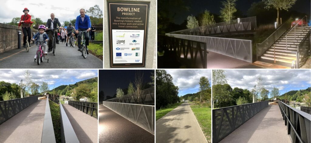
The Bowling Harbour project is another step towards transforming the National Cycle Network into a true, traffic-free network of paths for everyone; connecting cities, towns and countryside. Bowling Basin is a key link along National Cycle Network Route 7 and the long-distance Lochs and Glens Way route. The project has opened up a stunning new traffic-free section of route using the old railway bridges, removed the need to cross a busy road and created a new, fully accessible point to join Route 7 with installation of a canal-side access ramp.

Visit the Walk Wheel Cycle Trust to find out more.

Updated on 10 October 2025
cycle path cycling design

Was this useful to you?

  • Happy
  • Normal
  • Sad

Share This Article :

  • Facebook
  • X
  • LinkedIn
  • Pinterest
Clyde Walkway – Use of Smart Surface® Soil Stabilisation TechniqueWelcome to the SATIN Case Studies

Copyright © Scottish Outdoor Access Network

Privacy Policy

Scroll